Welcome to the Road
The C7 Road is an ancient trackway, now a ‘C’ class road, linking the port of Newhaven with the ancient town of Lewes.
Once an important transport route between London and the Channel ferry port of Newhaven, from there a sail to Dieppe, and on to Paris. Transformed from a track to a paved road in the 1930’s, it was one of the first in the UK to be covered in tarmacadm. It has never lost its rural nature as it curves around field boundaries and trackways, or slipping past villages that are so quiet.
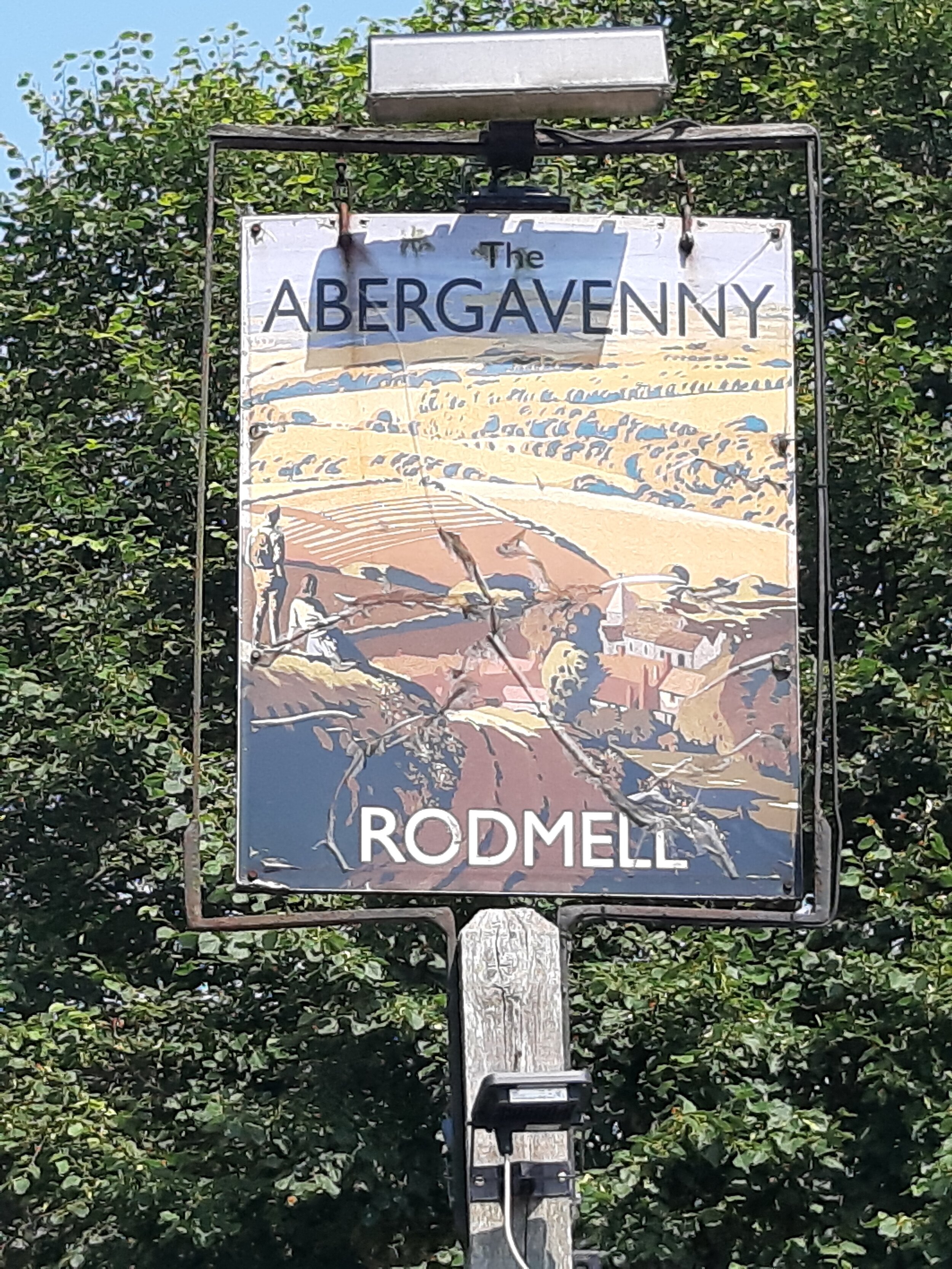
Along its five-mile route are three working farms, one vineyard, two pubs, three Norman churches and one Saxon age church. There are also two sites of special scientific interest which have been designated due to the rarity of the flora and fauna that inhabit them. In Rodmell is the home of Virginia Woolf, author, and now a National Trust Property being also a site of pilgrimage for people who wish to pay homage to her and her work. There are campsites and pubs, bed and breakfast accommodation and just off Southease village the only Youth Hostel on the South Downs Way. Speaking of which the South Downs Way crosses the C7 and so does the Greenwich Meridian, splitting the hemisphere into east and west.
William Rees Jeffreys and the Lewes to Newhaven Road
There can be no doubt about the contribution made by William Rees Jeffreys to the improvement and development of roads in the UK and elsewhere. We discovered his direct connection to our project while researching the history of the C7, which is the Lewes to Newhaven road. For centuries this narrow, winding track was the only direct land route between the market town of Lewes and the fishing village of Newhaven, with the Ouse River serving as the alternative direct transport route as the railway didn’t arrive in Newhaven until 1864.
Newhaven officially became a port in 1882, in recognition of its importance for shipping and its direct ferry service to Dieppe, and historic Lewes eventually became the County Town of Sussex. The 7 mile-long road connecting them then passed through six farming villages with their grand manor houses, Saxon churches, mills and small businesses.
The road remained unfinished until, in the early 20th century, William Rees Jeffreys, representing the Cyclists Touring Club, used his considerable influence “to secure the improvement of the road used by cyclists on their way to the Continent.” The result was that, in 1911, the Road Board agreed a scheme of improvement with the East Sussex County Council which was estimated to cost £33,619. Work was begun in 1914, paused during the years of WW1 and was finally completed with water- bound tar applied in 1923 at a total cost of £91,000. Several years later the road was surfaced with tar-bound macadam by East Sussex County Council.
In 1922 when, with the involvement of Mr Rees Jeffreys, the UK road classification system was introduced, the Lewes to Newhaven Road comprised the southern end of the A275. This designation remained unchanged until the mid-1970s when the A27 Brighton to Polegate Lewes-bypass was constructed and the A26, which originates in Maidstone, Kent, was extended to Newhaven over the route of the existing B2109 for the purpose of accommodating HGV traffic originating in Newhaven Port and along the south coast.
When this happened, the Lewes to Newhaven Road was reclassified as the C7 and HGVs were prohibited from using it so that it would revert to a quiet rural road serving local residents. However, this goal has never been achieved. While the A26 records an average volume of 16,000 vehicles/day, the C7 still accommodates 10,000 vehicles/day with an average speed in excess of 50mph. This is a source of great concern for local residents when they turn onto the C7 from their villages where visual splays are very restricted. In addition, only the most determined cyclists will use the C7 in preference to safer cycleways because, as observed by Mr Rees Jeffreys, “they are boycotted by a certain type of cyclist who imagines that by using them he is jeopardising his lawful right to the public highway in general.”
In recent years, the East Sussex Highways response to these concerns has been the reduction of speed limits in limited locations along the road and the introduction of additional speed signs and roundels as well as the construction of vertical deflection devices, gateways, and pedestrian islands. These measures have served to deface the local roadside environment while making no measurable contribution to the safety of the C7.
It is because of residents’ longstanding concerns about road safety that our community group is proposing to commission a road traffic design study which will recommend corrective measures for improving the safety of the C7 for all road users while restoring and retaining its rural nature.
The final word on the subject of road safety is an observation made by Mr Rees Jeffreys when he was commenting on the recommendations made by the Maybury Committee on the Taxation and Regulation of Road Vehicles in 1922. He stated that: “As a member of the Committee I agreed to the recommendations but doubted if they went far enough. Is not safety on the road to be secured, in the main, by the provision of fool-proof roads of modern design”?
NB. All quotes attributed to Mr Rees Jeffreys are to be found in his book, The King’s Highway, 1949.

A sense of place
What sets the C7 apart from other roads in the area? Firstly if you are a visitor to the National Park arriving by ferry then Newhaven is the only port that brings you directly to it. Secondly is the fact that it links Newhaven to Lewes, taking the visitor directly into the National Park and opening up views along the Ouse north to Lewes and east to Mount Caburn and Glynde. The route follows this ancient drove road as it edges field boundaries and trackways, lifting and falling tracing the slope of the chalk hills.
Along its five-mile route are three working farms, one vineyard, two pubs, three Norman churches and one Saxon age church. There are also two sites of special scientific interest. In Rodmell is the former home of Virginia Woolf, author, and now a National Trust Property being a site of pilgrimage for people who wish to pay homage to her and her work.
It is crossed by the Greenwich Meridian, separating east from west.
The road is bounded to the west by the South Downs (on top of which runs the national trail of the South Downs Way). To the east, runs the River Ouse, tidal as far as Lewes, and until 50 years ago used for the transportation of goods including iron ore from the Weald of Kent, wool and timber and bricks made and fired in Piddinghoe.
People have lived and worked along the Ouse Valley for 30,000 years. Three of the villages along its route are mentioned in the Domesday book, each with their own church already built and being used for worship at the time of recording. Stone age, bronze age, iron age and roman artefacts have been found in the fields that lay beside the road and Lewes, with its destroyed Priory and Saxon age twittens is constantly churning up Medieval age artefacts. Looking at the flood plain and the Brooks, the landscape shows the diggings of medieval age through to modern day drainage work and along the road itself, following closely the contours are second world war pill boxes, some almost hidden in the hedges.

A sense of being
Two sites of special scientific interest lie on the route of the C7; one rich in downland flora and fauna, the other a wetland environment, rich in birdlife and invertebrates. The latter located on the flood plain of the River Ouse, between Lewes and Southease is called the Brooks. The Brooks support a wide diversity of invertebrates, with water beetles being particularly well represented. There are also several rare snails, flies and moths. The ditches which cut through the river alluvium on the floodplain vary in salinity from fresh spring fed ditches in the west, to brackish water adjacent to the tidal River Ouse. This variation together with the cyclical clearing of ditches produces a mosaic of habitats, which support a wide diversity of invertebrates
Kingston Escarpment comprises two separate areas of chalk downland on the steep scarp slopes south of Kingston. This site is important for its chalk grassland, a habitat type which is rapidly becoming rarer owing to widespread agricultural improvement, and for the rich invertebrate fauna the grassland supports including a rare grasshopper and an uncommon chalk downland butterfly. In addition orchids are prevalent as are the flowers reminiscent of the past - Speedwell, Healall, Campion and herbs including Oregano, sage and Burnette.


A sense of living
An essential component of developing the story of a place is unlocking the embedded thoughts and memories of the people who work and live there. Landscapes are living places and the roads that move through them are as much a part of that landscape as the buildings that inhabit them or the trees that grow on them. People’s words have the effect of grounding us, making us stop and slow down and take notice. They capture the essence that is evaded in words or signs or monuments and they make the place feel real. Looking at commentary from the sustainable tourism strategy it is quite clear that these comments are aligning themselves with the ‘story of Englishness’ through to ‘Connecting Experiences’.
‘I remember cattle being driven along this road twice a day for milking’
‘American GI’s used to speed along this road in the war – it was great to see them. If you look closely you can still see pill boxes in the hedges – they were scared that the invasion was going to come from Newhaven’
‘Before D day there were tanks lined up turret to turret along this road, all the way back to Lewes. Newhaven was the embarkation point.’
‘You would be surprised at the number of cyclists who use it’
‘it’s a shame that its become so busy, we seem to have lost something – it would be lovely to get it back’

Places to eat, drink, sleep